Locations

Darvaza
Miracle in the Sands of the Karakum Desert Photos and videos with the mysterious name "Gates of Hell" are very popular on the Internet. They show fire erupting from underground in the middle of the desert. The sight of flames burning among the yellow sands of the desert fascinates and intrigues even seasoned travelers. But few people know how exactly this miracle of nature, located 266 kilometers north of the city of Ashgabat, came into being. In 1971, in the Karakum Desert, not far from the small village of Darvaza, whose name means "gate" in Turkmen, they began drilling an exploratory well for gas. During the drilling, an incident occurred: geologists accidentally opened an underground cavity, into which all the equipment fell along with the drilling rig and transport. People were not hurt, but natural gas burst out of the cavity. In order not to cause problems for the local residents of that very village of Darvaza, geologists decided to set the gas on fire, hoping that it would burn out completely in a few days. Weeks, months and years passed, and the fire continued to burn without dying down. In 2004, by order of Turkmenbashi, the village was moved to another location, and the Darvaza gas crater continued to burn. It is still burning today. No one knows how long this will last, whether the gas reserves will finally run out or whether the fire pit will eventually be filled in, because gas is a valuable resource, and here it is being wasted for several decades. Nevertheless, the Darvaza gas crater remains one of the most interesting and mysterious attractions of Turkmenistan, attracting many tourists every year. Darvaza Gas Crater, Gates of HellDarvaza Gas Crater, TurkmenistanDarvaza Gas Crater, Turkmenistan If you drive up to the "Gates of Hell" on a clear day, it will seem like an ordinary hole in the ground, not at all deserving of its dark mystical name. Only when you get closer will you see hundreds of tongues of fire blazing in the seventy-meter crater. Gas breaks out to the surface through the sandstone and ignites, further heating the already hot air. If you visit this attraction in the early evening, you can fully enjoy the mesmerizing spectacle of the crater slowly plunging into darkness and the orange tongues of flame - all against the backdrop of the setting sun. There are several more holes around the crater, one of them filled with turquoise liquid. It is better to examine the sinkholes before dark and very carefully: they crumble heavily along the edges, and the high air temperature and smell of natural gas are very noticeable nearby. Darvaza gas crater, Turkmenistan Darvaza gas crater, Turkmenistan Darvaza gas crater, Turkmenistan The Darvaza gas crater is very different from many natural attractions around the world, primarily in its sense of peace and pristine nature: there are no paid parking lots, pedestrian paths, fences or stalls selling souvenirs. There is only desert around, and there is not a soul for many kilometers. The only option for food is a yurt camp built near the Darvaza crater. You can try to buy essentials in the village of Yerbent, 90 km to the south. But do not count on luck, and it is better to take everything you need on the way out of Ashgabat. Darvaza Gas Crater, TurkmenistanDarvaza Gas Crater, TurkmenistanDarvaza Gas Crater, Turkmenistan When driving to the gas crater, keep in mind that regardless of the smooth, pothole-free road that runs from Ashgabat, the last few kilometers are on a sandy stretch that can only be driven in an SUV.
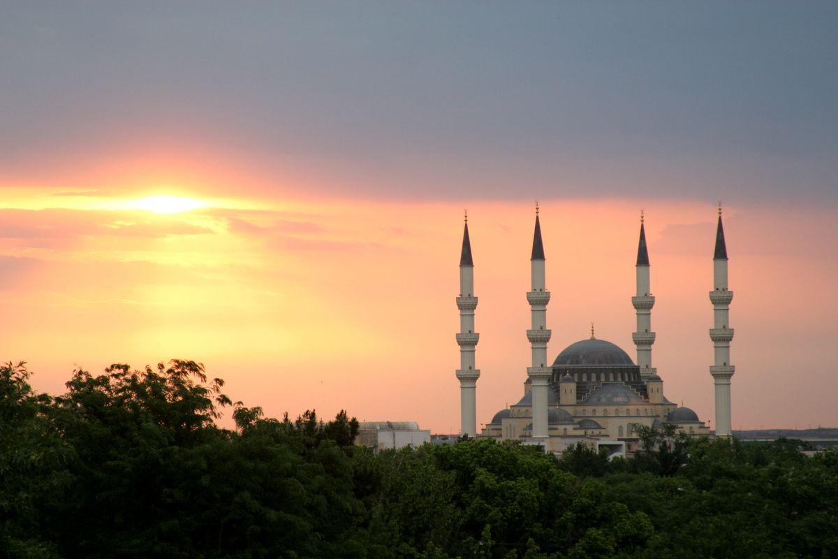
Ertugrulgazy Mosque
Ertugrulgazy Mosque - a combination of Islamic and Byzantine architecture Ertugrulgazy Mosque is one of the most beautiful Muslim mosques in Turkmenistan. Like all the buildings that appeared in Ashgabat during the period of independence, the mosque amazes with its size and richness of decoration. The mosque was built in the 90s of the 20th century in the center of Ashgabat, on Azadi Street. Therefore, this building is also called the Azadi Mosque. Ertugrulgazy Mosque is the largest mosque in Ashgabat and can simultaneously accommodate up to 5 thousand people. It is built in the Turkish style and named after Oguzkhan Ertugrul - the father of the first ruler of the Ottoman Empire, Osman. The grand opening of the mosque took place in 1998. It is decorated with four snow-white minarets, and externally it resembles the famous Blue Mosque located in Istanbul. The exterior and interior decoration of the Ertugrulgazy Mosque is done in the old Islamic-Byzantine style and amazes with its magnificence and sophistication. Inside the mosque there is a huge courtyard with a fountain, and the prayer hall is replete with paintings, gilding and stained glass.
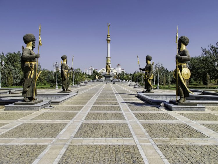
Independence Monument of Turkmenistan
The main tourist attraction of the capital of Turkmenistan can safely be called the National Park of Independence with the symbol of modern Ashgabat installed in it - the Independence Monument, the tallest building in the country (popularly called the "Eight-legged"). The base of the snow-white monument is a hemisphere, which is a symbolic image of a traditional Turkmen yurt. Rivers-fountains flow down all eight "legs" of the yurt dome and partially along its surface. The upward-reaching column is decorated with five-headed eagles and ends with a gilded spire, crowned with a crescent with five stars - a symbol of the unity of the five largest Turkmen tribes. The total height of the monument is 118 meters, and this number is not accidental: it is a derivative of the sum of two numbers: 27 + 91, denoting the Day of Independence - October 27, 1991. Five main entrances, guarded by formidable statues of warriors with gilded spears and sabers, allow you to get inside the monument, where the Museum of National Values is located, striking in its luxury of decoration. This museum contains beautiful examples of jewelry art, cold arms, firearms, a numismatic collection. Around the monument rise majestic statues of great rulers and military leaders, thinkers and artists of Turkmenistan, also decorated with gold paint. The ceremonial alley leading to the monument completes the majestic composition. In the evening, Independence Park is filled with the light of numerous lanterns, lamps, and spotlights, and all this white and gold splendor leaves a long-lasting mark on the soul of even the most sophisticated traveler.

The Museum of Ethnography and Local History of Turkmenistan
The Museum of Ethnography and Local History of Turkmenistan of the State Museum of the State Cultural Center of Turkmenistan was opened on May 18, 2009. The three-story building adjoins the main building of the museum. On the first floor of the museum there is an exposition dedicated to the nature of Turkmenistan, on the second - the ethnography of the Turkmen people. The Department of Nature and Local History consists of eleven sections. The first section is dedicated to the origin of the universe (where one of the valuable exhibits of the museum, the Kunya-Urgench meteorite, is located) and the evolution of life on Earth, where fossils and imprints of ancient organisms found on the territory of Turkmenistan are presented. Among them, it should be noted, are unique dinosaur footprints (age about 150 million years), discovered in the south-east of Turkmenistan (Khojapil plateau), the only traces of the ancient Arvan camel in the world (age 2.5 million years), located in the Western Kopetdag, a fragment of the jaw with a tooth of the Forest elephant and a lower jaw tooth of the Khazar elephant, which lived on the territory of Turkmenistan 100-200 thousand years ago. The second section of the museum introduces the physical and geographical characteristics of Turkmenistan. Here are presented: a climate map and a map of water basins, soil monoliths and minerals of Turkmenistan. From the third to the tenth section, the visitor gets acquainted with the regions of Turkmenistan. The journey begins with the Koytendag Mountains, to which the exhibition includes the karst Karlyuk caves, the deep-water Kettekol Lake, etc. The north of the country is represented by the Kaplankyr and Sarykamysh Lake dioramas with their flora and fauna. In the south of Turkmenistan there is a unique place – Badkhyz and the reserve of the same name, created in 1941 to preserve kulans. In this section, a magnificent diorama introduces natural monuments: the Eroylanduz Lake and wild pistachio sparse forests. There is also a collection of insects and arachnids. One of the largest dioramas is dedicated to the Kopetdag Mountains, where the fauna and flora of the mountains are presented: bezoar goat, argali, Western Asian leopard, marten, brown bear, wolf and birds – white-headed vulture, goshawk, partridges and others.
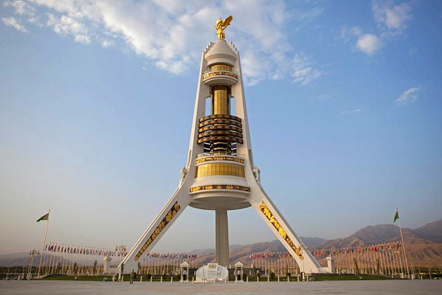
Monument of Neutrality
The Monument of Neutrality – an architectural symbol of modern Turkmenistan Some consider the Monument of Neutrality to be one of the most majestic structures in the world, while others are convinced that it is an architectural nightmare. Both call it one of the most striking symbols of modern Turkmenistan. The 95-meter structure, like a giant lighthouse, towering over the white marble Ashgabat, is the tallest monument in Turkmenistan. The structure rests on three pylons that form a tagan – a Turkmen stand for a hearth, symbolizing the strength of the state. The pylons are connected by disks and rings of different diameters and thicknesses, on which observation platforms are located. Funiculars run along two pylons, taking visitors to the first level of the monument. Here, at a height of 21.5 meters, there is a café-bar with an excellent view of the city. A transparent elevator takes everyone even higher – to a height of 50 m, where the upper observation platform is located. The structure is crowned by a 12-meter sculptural composition, on which, against the background of a fluttering flag, a golden statue of the first president of Turkmenistan, Saparmurat Niyazov, raises his hands to the sky. Monument of Neutrality, Ashgabat The Monument of Neutrality is faced with white marble, its pylons and lower cylinder are decorated with bas-reliefs with fragments of the history of Turkmenistan. The vertical part of the pylons is encircled by five bronze rings with national ornaments of Turkmen carpets, one for each Turkmen tribe. Previously, this giant structure slowly rotated around its axis, making a full revolution in 24 hours, and today it simply faces the city. Inside the monument is the Museum of Neutrality, the exposition of which is dedicated to the pages of the modern history of Turkmenistan. Around the Monument of Neutrality there is a landscaped park area with fountains, gazebos and cafes, and in the evening the giant structure shines in the lights of colored lighting. History of the Monument of Neutrality The idea of the Monument of Neutrality, which was initially called the Arch of Neutrality, is connected with Turkmenistan's acquisition of the international status of permanent neutrality on December 12, 1995. Thus, at the 50th session of the UN General Assembly, Turkmenistan was recognized as a neutral state pursuing a policy of non-interference in the internal affairs of other states and not participating in any military armed conflicts. December 12 began to be celebrated in Turkmenistan as Neutrality Day and in the same year the idea of building a monument in honor of this event arose. In 1996, by decree of Saparmurat Niyazov, the Turkish company "Polimer" began construction of the Arch of Neutrality. On December 12, 1998, the 75-meter Arch of Neutrality was officially opened in the very center of Ashgabat, where it stood until 2010. In 2010, a decision was made to move the arch to the southern part of the city. Over the next two years, the arch was uninstalled and moved to a modern highway - Bitarap Turkmenistan Avenue. The Arch of Neutrality was renamed the Monument of Neutrality, and the height of the structure became 95 meters, which is 2 meters higher than the famous Statue of Liberty in the United States.
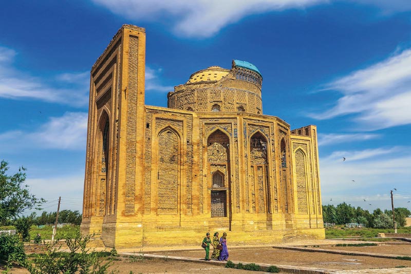
Kunya-Urgench (Koneurgench)
Kunya-Urgench (Koneurgench) is an ancient city, the first mentions of which date back to the 3rd-1st centuries BC. It is even found in the Avesta, the main book of the Zoroastrians. There the city is called Urva (Urga). Caravans of the Great Silk Road passed through here, and the Chinese called the city Yue-gan, although it was located on the territory of the state of Khorezm. In the 8th century, the city was conquered by the Arabs and renamed Gurganj. At the same time, the Khorezm ruler settled in Gurganj, declaring the city his residence. People began to move here, and soon the city became the second largest after Bukhara. In the early Middle Ages, Gurganj experienced a cultural boom. At that time, the city, located at the intersection of trade routes, was a large bazaar center. Famous scientists Abu Ali ibn Sina and Abu Rayhan Beruni lived here. They worked at the Mamun Academy. By the way, it was here that Ibn Sina began writing the "Canon of Medicine" and the "Book of Healing". At different times, Gurganj was conquered by the Mamunids, Anushteginids, and even Genghis Khan himself. The latter conquered Gurganj in 1221, having greatly destroyed the city. In the 14th century, the city came under the control of Uzbek Khan, the Sultan of the Golden Horde. Then, according to the merchant and traveler Ibn Battuta, Gurganj became the largest of the Turkic cities. In 1388, Gurganj was conquered by Tamerlane. In a few months of fighting, the city was practically wiped off the face of the earth. Soon after, almost all of Gurganj's residents left. Being torn apart, the city fell into oblivion. People returned here only in 1831. They began to build the Khan-Yab water canal. In 1924, the once majestic Kunya-Urgench became a Soviet settlement that became part of the Turkmen SSR. In 1992, the settlement was renamed Koneurgench, and 7 years later it was given the status of a city. Sights of Kunya-Urgench All the sights of Kunya-Urgench are located in the Old Town and are included in the UNESCO World Heritage List. Once upon a time, caravans of the Great Silk Road passed through here. Today, several buildings from the 11th-16th centuries have survived in the city. The Kutlug-Timur Minaret, built in the 14th century, is considered the tallest in Central Asia. Its length is 60-62 meters (the figures vary slightly depending on the sources). Once upon a time, the majestic minaret was part of a mosque that was destroyed. There is also a 14th-century mausoleum where Uzbek Khan's daughter, Tyurabek Khanum, is buried. The mausoleum is interesting for its dome mosaic panel depicting flowers and stars. It is believed that this ornament has no analogues. Kirk-molla Fortress is the most ancient monument of Kunya-Urgench. The fortress arose in the 3rd-2nd centuries BC and had a different name. In the 13th century, the ruler of the city decided to build a palace for scientists on this site, expecting that forty thousand mullahs (literates) would work here. You should look into the medieval city of Ak-Kala, the Mamun minaret, built in the 10th-11th centuries, the mausoleum of Khorezmshah Il-Arslan, built in the 12th century, and other architectural monuments located on the territory of Kunya-Urgench. Not many historical sights have survived to this day, and therefore we advise you to visit each one.

The Merv
The Merv Oasis (40 km from Mary) is one of the most ancient regions of Central Asia, the first to master irrigation. Therefore, it is not surprising that one of the largest cities of the ancient world, Merv (Margush, Margiana, Maru), grew up here. The origin of Merv is shrouded in mystery, but one thing is known for sure: the first written mentions of it appear in the Avestan chronicles around the 8th-6th centuries BC. The chroniclers did not skimp on bright epithets, calling it "the soul of the king", "the mother of the cities of Khorasan", and, finally, "the city on which the Universe rests". Omar Khayyam, As-Samani, Imamaddin Isfahani and other great thinkers of the Middle Ages lived and worked here. Modern ruins include at least five ancient settlements - Erk-Kala, Gyaur-Kala, Sultan-Kala, Abdullakhan-Kala and Bayramalikhan-Kala. Most of them are badly damaged, some are just heavily eroded earthen mounds, but even taking this into account, Merv continues to be one of the most unique historical monuments. Among the most interesting historical monuments, one can note the mausoleum of Sultan Sanjar Dar-al-Akhir (1140 AD), whose name is associated with the former heyday of the Great Seljuk Empire. With a height of almost 40 m, the monument amazes the imagination. The legendary dome, built from two thin brick shells, gives this medieval "skyscraper" a special uniqueness. Other famous Merv monuments: Sultan-Kala, the citadel of Shazriar-Ark, the ruins of the walls of Abdullakhan-Kala (XV century), the ruins of the fortress and towers of Bayramalihan-Kala, the ruins of the Kyz-Kala fortress (VI-VII centuries AD), the mausoleums of Al-Hakim ibn Amir al-Jafari and Buraidah ibn al-Hussein al-Islami (XV c, a place of pilgrimage), the mausoleum of Muhammad ibn Zeid (XII century), the Talkhatan Baba complex with the mausoleums of Talkhatan Baba, Imam Kasim, Imam Shafi and Imam Bakr of the Seljuk era, the Yusuf Hamadani mosque (XIII century, modern reconstruction was carried out in the 19th century), the ruins of the Yerk-Kala fortress (VI century), the ruins of a Christian temple and Buddhist monastery in Gyaur-Kala (ancient Antioch Margiana), the ruins of the Beni Makhan mosque (7th-12th centuries), the high walls of the fortress-like structures of Big and Little Kyz-Kala, the Kyz-Bibi mausoleum, as well as numerous remains of baths, palaces, ceremonial halls and other structures. Also worthy of attention are the mosques of Dandankan and Talkhatan-Baba. (12th century), the keshk (fortified house) of Akuyli-Koshuk (9th-13th centuries), the Haram-Keshk castle (9th-13th centuries), the Durnali settlement (1st-2nd centuries), and the Gebekly settlement. Many archaeological finds discovered during excavations of ancient cities can be seen in the beautiful Historical Museum of Merv. Nowadays, it is included in the UNESCO World Heritage List as the best-preserved ancient center of the Great Silk Road.
Gonur Depe
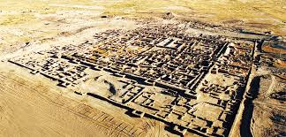
Not long ago, in the 90s, among the sands of the eastern Karakum, archaeologists uncovered a huge necropolis in the Mary oasis, dating back to the 2nd-1st millennia BC. There was a capital city here, now called Gonur-Depe (translated from Turkmen - Gray Hill), with its own palace and several temples that could compete with the buildings of Assyria and Babylon. Excavations of this place brought scientists and historians many amazing discoveries. The temple city kept its secrets in the sands of the desert for several millennia. Gonur-Depe was the largest settlement in all of Margiana. The complex was located on a low hill on the right bank of the Murghab riverbed. Excavations are still ongoing, and there are no exact figures yet, but according to preliminary data, the area of the ancient settlement ranges from 30 to 50 hectares. In this supposed "capital" there was most likely not a ruler with certain powers, who governed the entire country, but a spiritual leader - the high priest. People worshiped him not by force, but by free will, driven by faith. Gonur-Depe is the capital temple city of the country of Margush. Archaeologists have managed to discover convincing facts of spiritual rituals and traditions proving that the Gonur people adhered to the Zoroastrian faith. In the very center of the settlement there was a palace with many large ceremonial rooms, surrounded by powerful, thick walls and several square towers. Most likely, the high priest lived here. Around the palace, on all four sides, there were temple buildings connected by one wall. At the corners, the wall was also reinforced by square towers, but not as huge as in the surrounding wall of the palace. Outside the walls, on the southern side, there was a pool measuring 180 by 80 m and 2 m deep. On the northern and western sides of the temple complex there were two more pools, but smaller. All these structures were surrounded by another low and not so wide wall, reinforced with pilasters on the inner side. Scientists believe that this wall served as a kind of symbol of the limitation of the holy place from the rest of the world and was erected symbolically, and not for the purpose of defense. Archaeologists have found fragments of the facade parts of buildings, indicating that stone mosaics were used to decorate the walls. But the technique of the Gonur masters is unique in that initially the image on the wall was painted with paints and only then it was decorated with stones. Nowhere in the world has such a technology for laying out mosaics been found. A number of pottery workshops were also found on the territory of Gonur-Depe, indicating that such products were in great demand at that time.

The National Carpet Museum
The National Carpet Museum in Ashgabat is located in the city center near the State Association of Turkmen Hali. The museum was established by decree of the President of Turkmenistan in 1993 with the aim of preserving, reviving and creatively developing the time-honored tradition of Turkmen carpet weaving. Precisely when and where carpet weaving originated in the world remains a mystery. However, there is clear evidence that handwoven rugs have been produced in Turkmenistan since ancient times. Archaeologists have discovered loom equipment dating from the 4th to 3rd centuries BC, and during excavations in the Sumbar Valley in southwest Turkmenistan, 2nd-century BC bronze carpet knives were also unearthed. The first written record of the famous Turkmen carpet is from Marco Polo, the Italian traveler who visited Eastern Europe and Asia in the 13th century. He praised the carpets, calling them "the most delicate and beautiful in the world." The explorer was not alone in his adulation of the local rugs, which have long been distinguished for their beauty and durability, with the quality of the fabric counted among the finest in the world. Today in Turkmenistan, Carpet Day is observed annually to celebrate this national symbol. Turkmen traditional carpet motifs are present even on the national flag, where five famous gul patterns often found on Turkmen carpets can be seen on the flag’s vertical stripe. The shapes are arranged in a row to form a pattern, with supporting minor decor along the edge, and reflect the national unity of Turkmenistan. These five primary carpet designs are likewise depicted on the red band of Turkmenistan’s national emblem. Clockwise, they represent the Akhalteke, Salyr, Ersary, Chovdur and Yomut tribes, and together they also symbolize the friendship and unity of the Turkmen people. At the National Carpet Museum, visitors can learn about the history of local rugs, uncover their distinctive qualities and discover how to decipher the pattern of an authentic Turkmen carpet. The museum, which encompasses an area of 15,000 square meters, includes exhibition galleries, production halls, scientific departments, warehouses and conference rooms. The scientific departments, where employees meticulously restore old carpets and study their historical and artistic value, is one of the most essential branches of the museum. Specialists handle a diverse variety of local carpets, all of which are considered state property, from Esari Turkmen rugs to the famous Tekke carpets. Exhibition halls comprise a third of the museum’s total area. Items in the central folk art exhibits date back to the 17th -19th centuries, while 8000 carpets featuring various Turkmen rug motifs are augmented with unique displays and updated annually. The museum also guards the smallest handwoven carpet in the world, a keychain measuring .01 square meters and listed in the Guinness Book of Records, and one of the largest carpets on earth, which measures an astounding 301 square meters. The Turkmen Carpet Museum offers guided tours in both English and Russian. There is also a gift shop where you can purchase a high-quality carpet and receive the necessary documentation for export from the Turkmenistan Ministry of Carpets, issued directly through the museum. The National Carpet Museum in Ashgabat is an informative and colorful walk through the nation’s artistic history, one of many unique Turkmenistan experiences that travelers will not want to miss!
City of Mary
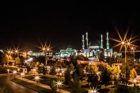
History of Mary Mary is considered the fourth city in Turkmenistan by population, today over 200 thousand people live here. It is located in the middle of the desert, in a large oasis. Mary was founded by the Russian military in 1884. The city was built near the ancient Merv, which is more than two thousand years old. Once upon a time, Omar Khayyam, Al-Khwarizmi, Enveri, As-Samani and other famous people lived in Merv. Today, Mary is considered the largest city in the country in terms of cotton growing and an important center for gas production. It is the gas industry that is the main source of income for Turkmenistan. Mary has unique museums. For example, the Museum of Turkmen Carpets exhibits the works of masters who pass on secrets from generation to generation. The patterns and designs of the carpets - Tekin, Ersarin, Yomud and Salor - differ from each other. The city also has a history museum with a large number of archaeological monuments. And at the stud farm in Mary, they breed one of the most famous breeds of racehorses in the world - Akhal-Teke horses. In Mary, there is a protected historical and architectural zone "Bayramali". It includes ancient settlements that were once the capitals of Merv. The most curious are: Gyaur-kala (3rd century BC - 8th-9th centuries AD) with the remains of an ancient Buddhist monastery and a Christian church, Sultan-kala (9th-12th centuries), Erk-kala (1st century BC), Abdullakhan-kala (15th century) and Bayramalikhan-kala (18th century). One of the main attractions of Mary is the mausoleum of Sultan Sanjar (1118-1157). The 40-meter architectural monument is crowned with a well-preserved dome. Other attractions of Mary - the ancient fortress of Shazriar-Ark, the remains of the fortress walls of Kaz-Kala, ancient mausoleums and mosques - will not leave even the most sophisticated traveler indifferent. Also in Mary is an Orthodox church built in 1900. The Pokrovskaya Church is built of red brick in the traditional Russian style. And not far from the city is the mosque-mausoleum of Talkhatan-Baba of the 11th century. It has survived to this day almost in its original form. Not far from Mary is the ancient settlement of Durnali. Buildings from the 9th-12th centuries have been preserved here, although the settlement itself existed much earlier. Archaeologists have found coins from the 2nd-1st centuries BC on the territory of the settlement. Near Durnali, 2 kilometers away, there are well-preserved parts of the Akuyli-Koushuk castle. The entire first floor, built of mud brick in the Middle Ages, has been preserved almost completely. Even the layout of the rooms has been preserved here.
Old Nisa
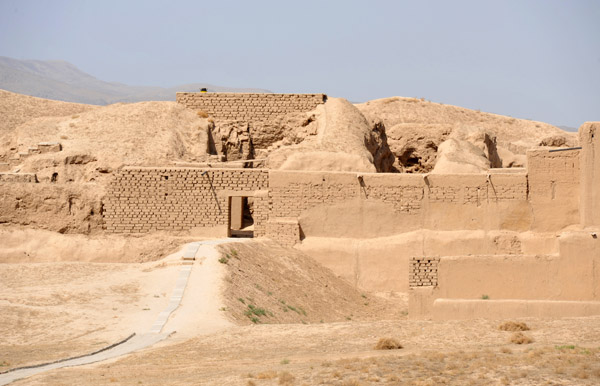
At the foot of the Kopetdag, 18 km west of Ashgabat, on the lands of the village of Bagir, there are ruins of ancient settlements. These ruins are the remains of the city of Nisa, the capital of the ancient Parthian state, mentioned by ancient and medieval authors. Nisa had a very large suburb, also surrounded by a rampart. Here were the estates of slave owners, with gardens and vineyards; like modern Bagir, Nisa was buried in their greenery. According to scientific data, Nisa existed at the turn of the 1st millennium BC - 1st millennium AD. The ruins of this ancient city consist of two settlements: the Parthian city in the valley - New Nisa, and the royal fortress on the hill - Old Nisa. The settlements are located one and a half kilometers from each other. In Old Nisa, palace and temple buildings were concentrated. There was also a treasury, a huge wine cellar and warehouses with numerous supplies. The fortress walls were 8-9 meters thick at the base and were reinforced with 43 rectangular towers. In the 1st millennium BC, the current district of the Turkmen capital was part of Parthiene, the land of the "Parthians" or "Parthians". The first historical mention of Parthiene is contained in the Avesta, the sacred book of Zoroastrianism. Parthiene is also mentioned in the Behistun inscription of Darius Hystaspes I (6th century BC); at that time it was one of the tax regions - satrapies of the powerful state of the Achaemenids. In the 4th century BC. Parthiene was part of the empire of Alexander the Great, and soon after his death, of the Hellenistic state of the Seleucids. In the middle of the 3rd century BC, a number of Central Asian peoples revolted against the rule of the Greeks, resulting in their secession from the Seleucids. Parthiene was the center of one of these rebellions, led by the brothers Arshak and Tiridates. On the basis of a coalition of local tribes and peoples, they founded an independent Parthian kingdom, which for about four and a half centuries was headed by representatives of the dynasty, which called itself by the name of its founder, the Arsacids.
Kutlug-Timur Minaret, Kunya-Urgench
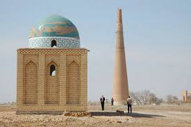
Grand, majestic, powerful... What epithets are not heard about this unique structure from the Middle Ages. And it is really so! Reaching a height of 60 meters, the Kutlug-Timur Minaret in Kunya-Urgench is the tallest monument in Central Asia, "surpassing" even the Sultan Sanjar Mausoleum. The minaret is a conical column. The slender, tapering round trunk is dissected by eighteen belts (stripes) painted with ornaments and three belts of inscriptions in "kufi". In the past, the minaret had a wooden lantern of the Iranian type, which burned down in a fire. A spiral staircase of 145 steps leads to the top of the minaret, which could only be reached from the roof of a mosque that no longer exists. The Kutlug-Timur Minaret lacks the rich decor of the Central Asian minarets of the 11th-12th centuries, but surpasses them in the boldness of its construction: height and slender proportions. Scientists are still debating the age of the minaret. Some believe that the foundation and construction of the minaret were made during the reign of Kutlug-Timur, by order of the ruler himself. Others believe that they began to build it under Shah Mamun (11th century). There is also information that it was built during the time of Sultan Mahmud of Ghazni (998-1030). It has only been established that it (and not the Mamun minaret) survived the destruction of the city by the Mongols in 1221. But the dome of the minaret, which is a valuable example of architecture, was badly damaged and was subsequently restored.

Erk-Kala, Merv
Erk-Kala was the center of ancient Merv. The fortress walls of Erk-Kala have somewhat sagged under the earthen deposits, but still retain their height and power. This makes Erk-Kala stand out from other fortresses. Currently, the height of the fortress walls with steep slopes and clearly carved towers reaches 25 - 29 m. The area of the fortress is about 20 hectares. The fortress was a massive round structure, at first glance without an entrance. In fact, the only entrance here was located on a hill (on the southern side of the fortress). Inside the settlement, the remains of the ruler's palace rise. On the northern part of Erk-Kala there was a city square (intended for the gathering of large masses of people). It was Erk-Kala that once received the name of the city of Margush.
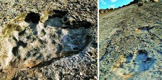
Dinosaur Plateau
Dinosaur Plateau, also known as the Khodzapil-Ata Tracksite, (Turkmen: Dinozawrlar platosy) is a large limestone slab from the Kugitang Svita that is located on the slope of the Köýtendag mountains in the Lebap Region of Turkmenistan. The area is notable for preserving the largest concentration of dinosaur footprints in a single area.

Yangi-Kala Canyon
Yangi-Kala Canyon (Turkmen: Ýangy-gala ; "fire fortress") is a canyon in Turkmenistan , one of the country's attractions . It is located in the Balkan region , 160 km east of the city of Turkmenbashi and 165 km north of the city of Balkanabat. According to scientists, the bottom of the canyon was once flooded by Kara-Bogaz-Gol in ancient times. The color of the canyon rocks is predominantly red, so local residents call it " Gyzyl Dag " (Red Mountains). The canyon rocks reach a height of 60 m to 100 m. The canyon has become a popular tourist attraction.